Internal tides are baroclinic wave trains generated at tidal intervals by barotropic tidal currents when they flow over steep ocean-bottom topography [e.g., Wunsch, 1975; Phillips, 1977; Garrett, 2003]. In contrast to the more familiar wind-driven waves at the ocean surface, internal waves propagate along interfaces such as the thermocline in the density-stratified ocean and are characterized by slow speeds and large amplitudes that serve as the restoring force for oscillations [e.g., Munk and Wunsch, 1998]. Internal waves can cause dramatic vertical displacements in density stratification, considerably enhancing vertical water mixing; as such, they play a significant role in affecting global climate [e.g., Polzin et al., 1997; St. Laurent et al., 2001, 2003; Garrett, 2003; Jayne et al., 2004; Levitus et al., 2012].
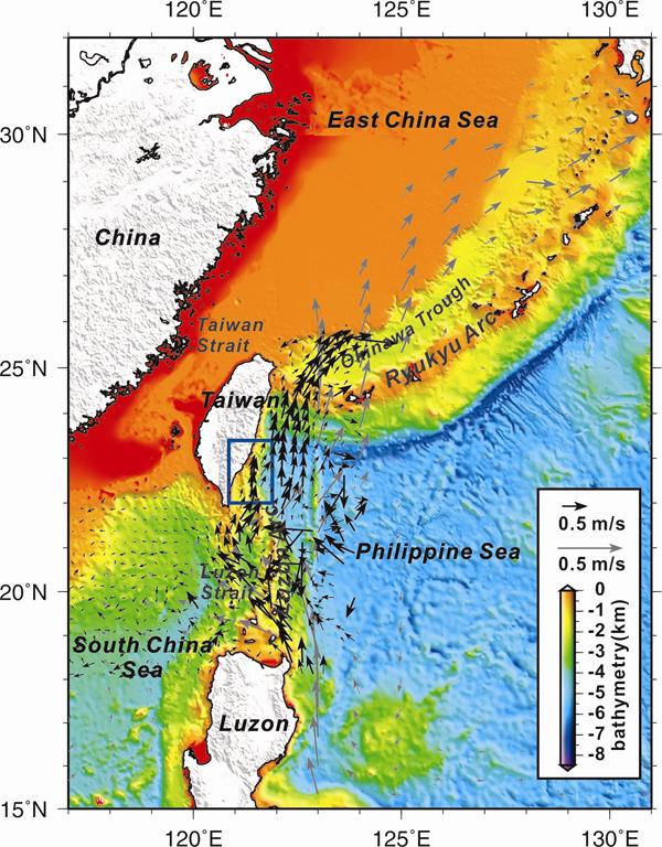
A wealth of knowledge of the ocean’s internal tides has accumulated; however, in situ monitoring of internal tides in the deep sea is generally sparse. This monitoring is particularly limited at the water-solid Earth interface, where the tidal forcing and energy dissipation actually occur and where models make idealized assumptions in terms of boundary conditions [e.g., Pedlosky, 1996; Wunsch and Ferrari, 2004]. In this study, we conducted an ocean-bottom geophysical experiment at four sites on the two flanks of the Lanyu Ridge; this experiment covered 71 days in May-July 2011. Each station consisted of an ocean-bottom seismometer (OBS) with 3-D geophone recording and a compact high-sensitivity temperature logger (CHTL). The study area, which is located just north of the Luzon Strait (Figure 1), lies at the edge of one of the world’s most active “hot spots” of internal wave generation [Liu et al., 1998; Egbert and Ray, 2000; Hsu et al., 2000; Farmer et al., 2011; Chen et al., 2011; Alford et al., 2015]. In addition to tectonic earthquakes, the retrieved data provide continuous in situ records of ambient water temperature (from the CHTL loggers) and “tremor” motions (from the OBS geophones). These temperature variation and mechanical agitation signals reveal wave motions with strong tidal periodicities, mostly M2, at seafloor depths exceeding 1,000 m (Figure 2). The variability in the amplitude and phase is irreconcilable with regular barotropic tides but suggests that deep-sea internal tides are responsible for the observations. The propagation speed of the ocean-bottom M2 internal tides is found to vary over a range of 1 to 2+ m s-1 (Figure 3), somewhat slower than the surface internal waves in the region.
We contend that the internal tides originate in the Luzon Strait and generally propagate to the northeast, sub-parallel to the coastline of Southeastern Taiwan. These internal tides are likely modulated by the Kuroshio Current [Jan et al., 2008], whose main stream flows northward over our study site. This scenario is well corroborated by hydrodynamic model simulations.
Three typhoons, Aere, Sungda, and Meari, passed nearby during the period covered by our experiment; the times of closest approach for these hurricanes were May 10, May 27-28, and June 24, respectively. Simulations have shown that storm-generated internal waves can affect bottom waters at depths well over 1 km [Simmons et al., 2012]. We examine key signatures of the typhoons, especially those of the strong Category 5 Typhoon Sungda. Upon the passage of Typhoon Sungda, two sites in the Taitung Trough (Stations A and B in Figure 2) experienced simultaneous increases in ocean-bottom temperature that were followed by strong oscillations of up to 0.5°C at the O1 tidal period (25.82 hours), likely reflecting a standing oscillation excited within the semi-closed ocean basin.
Our seismological experiment in fact yielded telltale oceanographic information for the internal tides at the ocean bottom, a critical dynamic interface of oceanography that is in need of more detailed monitoring.
(a)
(b)

(c)
Figure
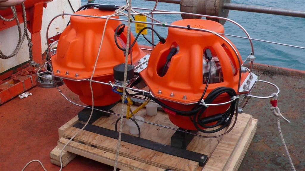
1. (a) Seafloor topography
around Taiwan and the geography of the offshore experiment from May 5 to July 15, 2011. The small gray
arrows show the mean speeds of the Kuroshio current (from the Ocean Data Bank
of the Ministry of Science and Technology, Taiwan; http://www.odb.ntu.edu.tw/). The inset shows the study site. Panels (b) and (c) show the CHTL logger and OBS instrument used in
this study, respectively. Both instruments were developed at the Institute of Oceanography, National
Taiwan University (NTU).
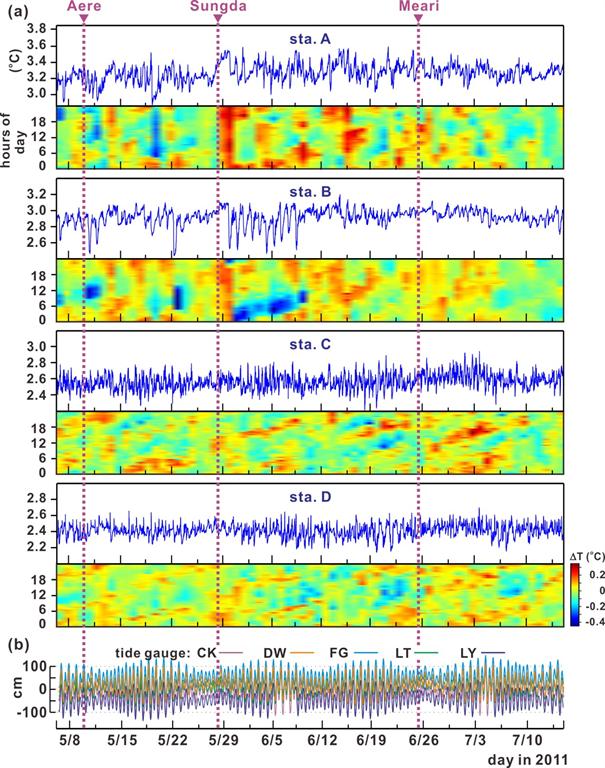
Figure 2. (a) The four complete CHTL time records of bottom-water ambient temperature during the 71 days covered by our experiment. The colored panels show the records divided into 24-hour segments and plotted vertically against days; these panels reflect the phase shift of the M2 tidal signals. The times at which the three typhoons passed nearby are indicated at the top of the figure. (b) Sea level records provided by five nearby tide gauges. These records show diurnal and semidiurnal tides, primarily M2, which occur essentially simultaneously.
Figure 3. (a) Upper panel: the M2 tidal phase of the four CHTL temperature records as a function of time with reference to that at tide gauge FG. Lower panel: As above but for stations A, C, and D relative to B, showing the respective phase lags. (b) The estimated horizontal velocity vector of the M2 plane wave across the station array during the time period covered by the experiment.
Reference
Chang, E. T., Chao, B. F., Chen, G., and Liau, J. (2016). Internal tides recorded at ocean bottom off the coast of Southeast Taiwan. Journal of Geophysical Research: Oceans, 121(5), 3381-3394. DOI:10.1002/2015jc011370
Emmy T.Y. Chang
Professor, Institute of Oceanography